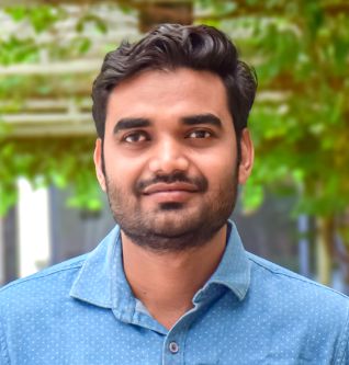
Dr Swakangkha Ghosh
- Assistant Professor
- Geographic Information Systems
Dr. Swakangkha Ghosh earned her PhD degree in active tectonics and paleoseismology from the Indian Institute of Technology (ISM), Dhanbad. However, majority of the work related to her Ph.D. was completed from Wadia Institute of Himalayan Geology, Dehradun where she was working as a research scholar in an ISRO funded project. She has competed her master’s in Applied Geology from Dibrugarh University, Assam and her bachelors in Geology (Hons.) from North Eastern Hill University, Meghalaya.
Prior to joining NU, Dr. Ghosh worked as a Research Scientist at the North-Eastern Region node for Disaster Risk Reduction (NER-DRR) of the North-Eastern Space Applications Centre (NESAC), Department of Space, Meghalaya. Her research mainly focussed on applying remote sensing and GIS techniques for the comprehensive analysis and management of various natural hazards in north-eastern states of India. At NESAC, she was also actively engaged in various outreach and capacity building activities.
Her current research focuses on assessing earthquake hazards, especially in the Himalayan region. She believes in taking up an interdisciplinary approach using remote sensing, geophysical techniques, and geochronology to assess the paleoseismic scenario of any region.
Dr. Ghosh has to her credit several peer-reviewed research publications in various national and international journals.
Qualifications
- Ph.D, 2024, Active tectonics and Paleoseismology, Indian Institute of Technology (Indian School of Mines), Dhanbad.
- M.Sc Applied Geology, 2013, Dibrugarh University, Assam.
- B.Sc. (Hons), Geology, 2011, North Eastern Hill University, Meghalaya (Gold Medalist).
Experience
- Total – 9+ years
- Industry – 2 Years, 09 months
- Research – 7 Years
- Teaching – 08 months
Courses taught
- Geospatial Field Techniques and Application Integration
- Geoinformatics for Disaster Management
- Geoinformatics for Environment
Research Area(s)
- Paleoseismology and Active tectonics
- Quaternary Geology
Consulting Area
- Earthquake hazard analysis
- Landslide mapping and monitoring
- Active fault mapping through the integration of geophysical and remote sensing techniques
- Geodesy and surveying
- Drone data processing and interpretation
Publications
Research Papers
- Joshi, M., Naik, S. P., Mohanty, A., Bhadran, A., Girishbai, D., & Ghosh, S. (2023). First hand observations from the April 28, 2021 Sonitpur (MW 6.4) earthquake, Assam, India: Possible mechanism involved in the occurrence of widespread ground effects. Geosciences Journal, 27(2), 225-239. DOI: 10.1007/s12303-022-0032-z
- Ghosh, S., Philip, G., Prasad, A. K., Syed, T. H., & Mohanty, S. P. (2023). Towards quantifying the relative tectonic activity in the Trans- Yamuna segment of NW Himalaya. Geocarto International, 38(1), 2155712. DOI: 10.1080/10106049.2022.2155712
- T. Sivasankar, S. Ghosh, and M. Joshi, “Exploitation of optical and SAR amplitude imagery for landslide identification: A case study from Sikkim, Northeast India,” Environ. Monit. Assess., vol. 193, no. 7, Jun. 2021, DOI: 10.1007/s10661-021-09119-6.
- S. Ghosh, T. Sivasankar, and G. Anand, “Performance evaluation of multi-parametric Synthetic Aperture Radar Data for geological lineament extraction,” Int. J. Remote Sens., vol. 42, no. 7, pp. 2574–2593, Dec. 2020, doi: 10.1080/01431161.2020.1856963.
- Choudhary, S., Sen, K., Kumar, S., Rana, S., & Ghosh, S. (2021). Forsterite reprecipitation and carbon dioxide entrapment in the lithospheric mantle during its interaction with carbonatitic melt: a case study from the Sung Valley ultramafic–alkaline–carbonatite complex, Meghalaya, NE India. Geological Magazine, 158(3), 475-486.
- Goswami, T. K., Sarmah, R. K., Mahanta, B. R., Syngai, B. R., Das, T., Ghosh, S., & Borgohain, B. (2013). Deformation at lateral ramps of the propagating thrust sheet: Examples of the nature of Main Boundary Thrust in some parts of West Siang District, Arunachal Pradesh, India. South East Asian Journal of Sedimentary Basin Research, 1(2), 61-67.
Conference Papers
- D. Sarma, S. Ghosh*, A. Bharali, R. Bharali, N.G.R Singh, D. Barman, S. Sudhakar, “An innovative multi- disciplinary GIS based hydro meteorological approach of assessment of upcoming flood waves in tributaries of Brahmaputra Valley. Regional Conference on Geoinformatics for Early Warning of Disasters with special emphasis on NE Region”, hosted by ISG, Shillong Chapter, NEHU and Page 4 | 1 NESAC (Sept. 18-19, 2014).
- S. Ghosh*, S. S Kundu, K. Bhusan, “Seasonal groundwater variability in few selected sectors of North Eastern Region of India using GRACE”. National Geo- Research Scholars Meet, 2015 at Wadia Institute of Himalayan Geology, Dehradun.
- S. Ghosh*, G. Philip, N. Suresh, S. Kannaujiya and P. K. Champati Ray, “Remote sensing data analysis for mapping active faults towards earthquake hazard assessment in the Trans-Yamuna segment of north-western Himalaya”. ISRS-ISG National Symposium 2016, at Indian Institute of Remote Sensing, Dehradun.
- S. Ghosh*, G. Philip, S. Kannaujiya, N. Suresh, Champati ray P. K and T. H Syed, "Evidence for Quaternary Displacements in the Trans Yamuna Segment of the Doon Valley in NW Himalaya: Implications for Earthquake Hazard Assessment", at 9th International Conference on Geomorphology, New Delhi from 6th-11th November, 2017.
- L. Sardine Varay, M. Somorjit Singh, S. Ghosh*, G. Sharma, K. Bhusan, “Control of topographic parameters on seasonal landslides in Arunachal Pradesh using earth observation data”, Indian Society of Remote Sensing (ISRS) and Indian Society of Geomatics (ISG) Seminar on Advances in Remote Sensing and GIS Applications, 2018.
- S. Saha, S. Ghosh*, D. Bezbaruah, S. Singh, “Geomorphic Indices as a parameter for the appraisal of Active Tectonics: A DEM based study on Kopili River Basin, Assam, India. Conference on Recent Trends in Earth Science Research & Centennial Celebrations from Page 5 | 1 October 12 to 14, 2019, Banaras Hindu University.
Book & Book Chapters
- M. N. S. Ramya, T. Sivasankar, S. Ghosh, and G. Venkata Rao, “A Remote Sensing and GIS Approach Toward the Analysis of Patel Milmet Dam Burst, Kenya,” in Recent Technologies for Disaster Management and Risk Reduction, P. K. Rai, P. Singh, and V. N. Mishra Eds., Germany: Springer, 2021, pp. 265-274.
- Ghosh, S., Sivasankar, T., Anand, G, “Use of Remote Sensing in Lineament Analysis: Exploring its Potentials in a Humid Subtropical and Semi‐Arid Environment,” in Atlas of Structural Geological and Geomorphological Interpretation of Remote Sensing Images, A. A. Misra, S. Mukherjee Eds., John Wiley & Sons Ltd, 2022, pp. 147-156
Selected Publications
- Ghosh, S., Philip, G., Prasad, A. K., Syed, T. H., & Mohanty, S. P. (2023). Towards quantifying the relative tectonic activity in the Trans- Yamuna segment of NW Himalaya. Geocarto International, 38(1), 2155712. doi: 10.1080/10106049.2022.2155712
- Ghosh, S., Sivasankar, T., & Anand, G. (2021). Performance evaluation of multi-parametric synthetic aperture radar data for geological lineament extraction. International Journal of Remote Sensing, 42(7), 2574-2593. doi: 10.1080/01431161.2020.1856963
- Sivasankar, T., Ghosh, S., & Joshi, M. (2021). Exploitation of optical and SAR amplitude imagery for landslide identification: A case study from Sikkim, Northeast India. Environmental monitoring and assessment, 193(7), 386. doi: 10.1007/s10661-021-09119-6.
Awards & Recognition
- North Eastern Hill University (Gold Medalist), B.Sc. Geology Honors.
- IIRS-ISRO, Research Fellowship, 2015
Professional Activities & Achievements
- Young Geomorphologist (Grant holder) at the International Conference on Geomorphology, 2017 at New Delhi supported by IAG and EGU (Tectonics Group).
- 2023 International Summer School on Rockslides and Related Phenomena in the Kokomeren River Basin (Kyrgyzstan) supported by the International Consortium on Landslides (ICL) and International Program on Landslides (IPL), IPL-106–2 Project.
Memberships
- Indian Society of Remote Sensing (Life Member)
- Fault2SHA Community
- The Young Earth System Scientists (YESS) Community
- International Association of Geomorphologists (IAG)
Other Interests
- Photography, trekking, rockhounding, and cooking